Investigating a blue carbon demonstration site on primary production land
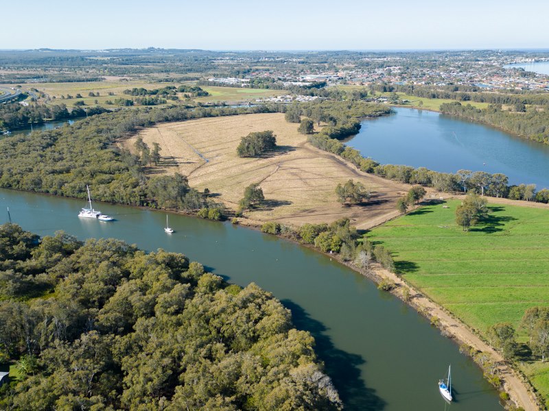 How the project will transform this 13-hectare peninsular paddock, adjacent to the Richmond River near Ballina, into a blue carbon demonstration site.
Overview
Why is this project important?
Climate change and sea level rise will have increasingly significant impacts for landowners and managers on the lowest lying parts of the coastal floodplains.
This is because current and historic increases in water levels, as well as increases projected for the near future, limit the rate and times when drainage can occur.
This change can reduce opportunities for traditional agricultural landuse on low lying land.
The MEMS Coastal Floodplain Prioritisation study shows that more than 640km2 of NSW coastal floodplains have ground surface elevations below 1 m AHD. This land is especially impacted as it is already below the height of the highest tides that occur on the NSW coastline.
The Blue Carbon Demonstration Project at Duck Creek will showcase new approaches that landholders might adopt to accommodate sea level rise on their land.
The project will help develop guidance materials and policy to support primary producers and landholders to transition to blue carbon farming.
Returning tidal flows to grow Blue Carbon ecosystems presents an option to adapt to sea level rise and build resilience to flooding in a way that produces a financial return.
The blue carbon method involves restoring blue carbon ecosystems by removing a tidal barrier such as a levee or floodgate on a waterway and reintroducing tidal flow to an area of land.
Projects registered and delivered under an approved Australian Carbon Credit Unit(ACCU) Scheme method are issued credits for the equivalent tonnes of carbon emissions captured and stored over the lifetime of the project.
The Blue Carbon Demonstration Project at Duck Creek is highlighted in the NSW Blue Carbon Strategy 2022 – 2027. This is a statewide initiative to support evidence-based projects and research to protect and conserve important blue carbon ecosystems.
What is blue Carbon?
Blue Carbon refers to carbon stored in coastal/marine ecosystems and includes mangroves, saltmarshes, and seagrass. These ecosystems are more efficient at sequestering carbon.
They provide longer term carbon storage than terrestrial ecosystems as they store most of their carbon below ground, within the soil.
What are Australian Carbon Credit Units?
One Australian Carbon Credit Unit (ACCU) represents one tonne of carbon dioxide stored. ACCUs are tradable units that can be purchased by the Australian government or businesses to offset their emissions.
The Australian Carbon Credit Units Scheme issues ACCUs to eligible registered projects that store or prevent the release of carbon dioxide into the atmosphere in accordance with approved methods under the ACCU Scheme.
What are co-benefits?
Co-benefits are other benefits in addition to carbon that can occur when tidal flows are re-established with a blue carbon project. They include cultural and recreational benefits, fisheries production, foreshore protection, water quality, and terrestrial and aquatic biodiversity value.
What are we doing?
The Blue Carbon Demonstration Site on Primary Production Land project is being undertaken at the DPI Duck Creek Research Station located on the Richmond River floodplain near Ballina.
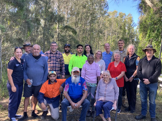
We are working with the Jali Local Aboriginal Land Council to transform a 13 ha peninsular paddock currently used for cattle grazing into an accessible blue carbon demonstration site.
Researchers monitoring both the recovery of expected co-benefits and the loss of agricultural productivity will gather and share the information with floodplain landholders and managers to help their planning as sea levels rise.
The project received funding from the Department of Climate Change, Energy, the Environment and Water in 2023 to deliver the project by 2026.
The project involves installing a boardwalk to ensure ongoing access through the site and removing a perimeter farm levee, restoring tidal flows, and allowing for the natural regeneration of mangrove and saltmarsh ecosystems.
The project will be registered under the tidal restoration of blue carbon ecosystems method ACCU Scheme. The project will initially occupy only the 13 ha point paddock, with the rest of the site remaining in agricultural production.
This will demonstrate how landholders and managers of low-lying properties can build resilience and adapt to sea level rise and more frequent flooding by incorporating blue carbon farming into their agricultural business enterprise.
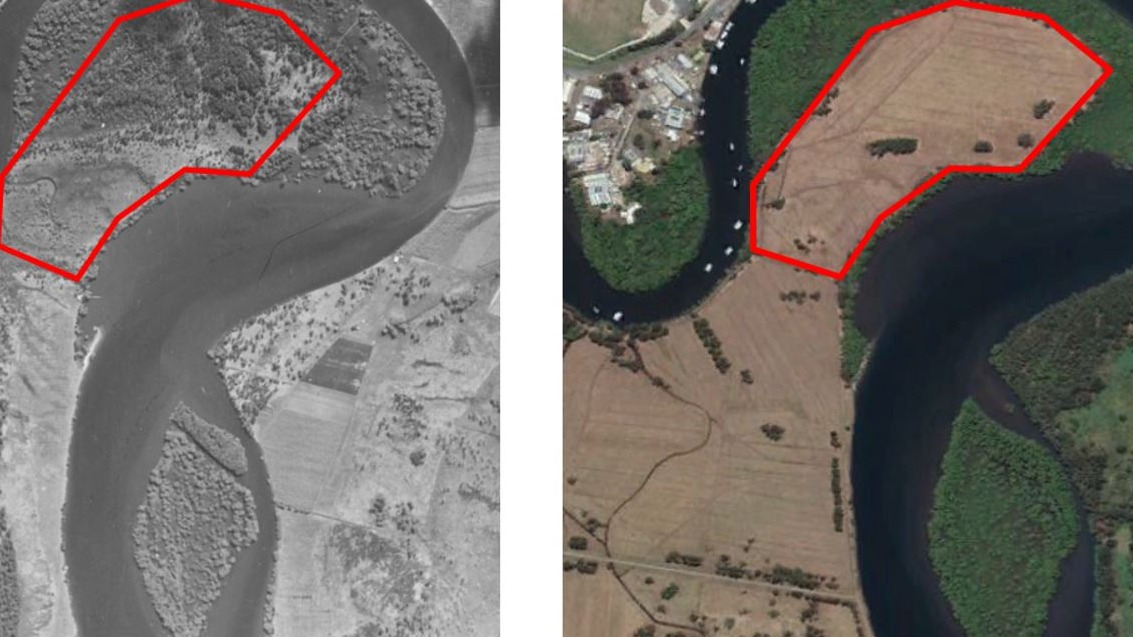
Aerial image comparison of the blue carbon project site showing the change in vegetation cover and land use between 1942 and 2020.
A key step for the project is registering the site and, if approved, administering it under the ACCU Scheme.
Following the completion of on-ground work, this will enable the carbon sequestered at the site to generate ACCUs.
On-ground works will involve removing a perimeter levee to restore tidal flows and ecological processes.
The recovery of expected co-benefits such as fisheries production, foreshore protection, water quality and biodiversity improvements will be monitored by researchers and compared to alternate land uses.
Cultural values of the site will also be assessed and recognised as part of the project.
Full delivery of this project is dependent on registration under the ACCU Scheme approved by the Clean Energy Regulator.
Broader applicability
The demonstration site shows how blue carbon can become part of a coastal farm business enterprise that improves resilience to flooding, is adaptable to sea level rise and grows financial and environmental co-benefits.
This alternative land use is especially important for owners and managers on low lying floodplains vulnerable to extreme events and climate change.
What have we achieved so far?
| Project deliverables | Status | |
|---|---|---|
| Required for registration under ACCU Scheme | Hydrological assessment and project extent mapping (PDF, 11184.57 KB) | Complete |
| Site history assessment | Underway | |
| Mosquito management plan | Underway | |
| Additional Research & Resources | Risk assessment of salinisation impact on adjacent paddocks | Underway |
| Aboriginal Cultural Heritage Assessment Due Diligence Report | Available upon request | |
| Farm management plan (PDF, 936.75 KB) | Complete | |
| Project and site inspection video | Complete | |
| Project factsheet (PDF, 443.89 KB) | Complete |
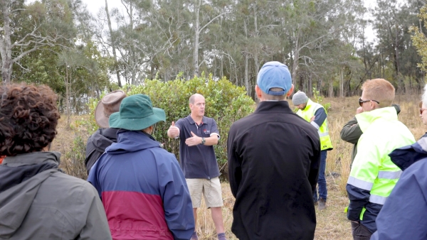
Site tours
The demonstration site is located on the DPIRD managed Duck Creek Research Station. Guided site inspections for groups of key stakeholders are available throughout the year.
World Mangrove Day - Blue Carbon Tour
Register to tour the DPI Blue Carbon project, learn about blue carbon, how it generates income and aids in mitigating impacts of climate change. There are two tour dates to choose from Friday 26th or Saturday 27th July.
Lead agency
Department of Primary Industries and Regional Development
Partners
- Department of Climate Change, Energy, the Environment and Water
- Jali Local Aboriginal Land Council
- Living Lab Northern Rivers
- Southern Cross University
- University of Wollongong
- NSW Health Pathology
- Local Government
Project updates
We celebrated World Mangroves Day with a Blue Carbon tour
11 August 2023